Back Healey (parokya) CEB Healey (Yorkshire du Nord) French Healey (North Yorkshire) Dutch Healey (North Yorkshire) Polish Healey, North Yorkshire Swedish Healey, North Yorkshire Turkish
| Healey | |
|---|---|
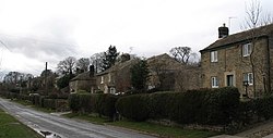
 The main, indeed only, street in Healey | |
Location within North Yorkshire | |
| Population | 100 |
| OS grid reference | SE181806 |
| Civil parish |
|
| Unitary authority | |
| Ceremonial county | |
| Region | |
| Country | England |
| Sovereign state | United Kingdom |
| Post town | RIPON |
| Postcode district | HG4 |
| Police | North Yorkshire |
| Fire | North Yorkshire |
| Ambulance | Yorkshire |
Healey is a small village and civil parish in the Harrogate district of North Yorkshire, England. It is situated in the valley of the River Burn, to the immediate west of Fearby. It is about three miles west of Masham in the Nidderdale Area of Outstanding Natural Beauty. There are several holiday cottages and four Grade II Listed buildings, one of which is Healey Mill, a former corn mill.[1]
The civil parish includes Leighton Reservoir, the hamlet of Leighton, the hamlet of Gollinglith Foot in the lower part of Colsterdale and a large area of Masham Moor, a grouse moor, rising to the summit of Great Haw, 6.5 miles (10.5 km) from the village at the western extremity of the parish. The population of the parish was estimated at 100 in 2013.[2][3]
- ^ Historic England. "Healey Mill (1132031)". National Heritage List for England. Retrieved 11 July 2015.
- ^ "Population Estimates". North Yorkshire County Council. 2013. Archived from the original on 13 January 2012. Retrieved 9 April 2016. In the 2011 Census the population of the parish was included with the parishes of Colsterdale, Ellingstring and Ilton cum Pott, and not separately counted.
- ^ "Civil Parish population 2011". Neighbourhood Statistics. Office for National Statistics. Retrieved 4 August 2015.
